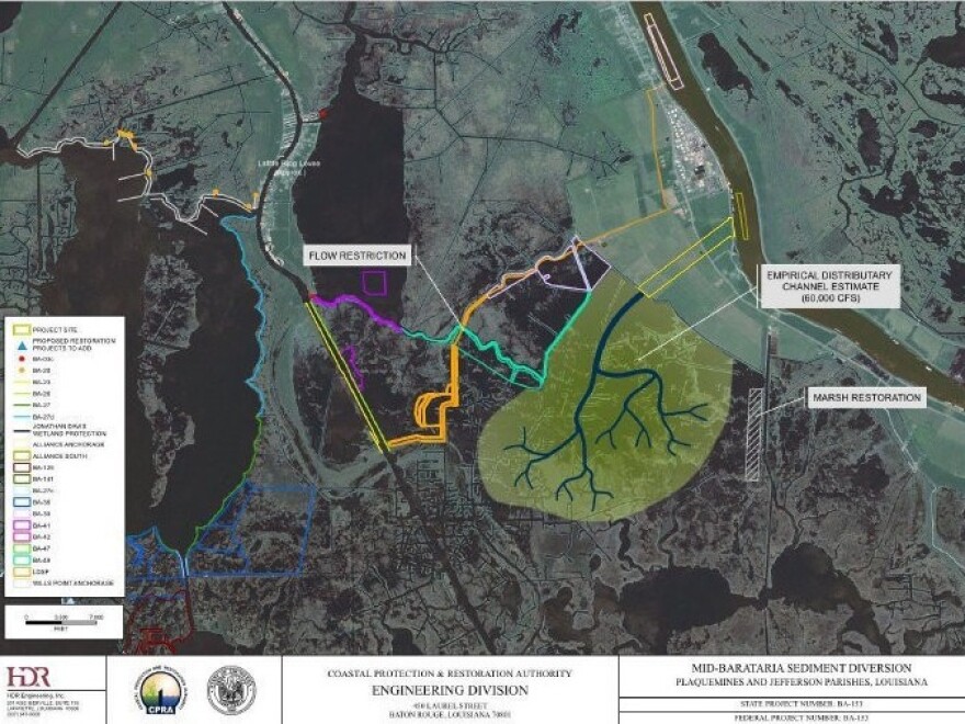
Over the past century, Louisiana has lost more than 2,000 square miles of coastline, leaving it more vulnerable to storms, flooding and sea level rise. State officials have been fighting back, building levees, artificial marshes and barrier islands. Now they want to harness the muddy Mississippi River, diverting its sediment-rich waters into shrinking marshes and wetlands.
An hour south of New Orleans, Albertine Kimble offers a tour of the sinking patch of land where she lives in rural Plaquemines Parish. She is 56, a retired local government worker with a passion for duck hunting.
We ride her ATV down an empty highway, then up the grassy slope of a 17-foot levee. The levee's job is to keep Kimble and her neighbors from flooding, and to keep the Mississippi River navigable for ships churning toward ports upstream.
From on top of the levee, the Mississippi River on the left is murky and brown, full of sand and dirt washed downstream from other parts of the country. To the right is Kimble's property, which tapers into open marsh. She says she can smell the difference between the two sides. The river smells fresh.
"Back there it don't," she says of the marshy side. "It smells rotten."
As in many places along Louisiana's disappearing coast, the marsh behind her house is dying. There are many reasons, including man-made canals and natural storm surges that brought in saltwater.
But one big problem has been a lack of sediment. An extensive line of levees has prevented the Mississippi River from flooding adjacent land and delivering the water and sediment that marshes need to stay healthy.
Kimble supports the state's plan to reconnect the river to the marsh. Waving her hand toward the Mississippi, she calls it "the salvation of Plaquemines Parish."
Louisiana officials want to create sediment diversions up and down the river. That means removing sections of the levee and directing some of that sediment-rich water through channels into nearby dying marsh.
The idea is that the sand and silt in the river will slowly pile up and build new land. Much of south Louisiana was built in a similar way as the Mississippi River repeatedly flooded its natural banks.
Many environmental groups support diversions. Many in commercial fishing don't. They say sending freshwater into the estuary could ruin the habitat and threaten their jobs.

Historical data suggest the river won't keep up
But the state is moving ahead. Along with Louisiana State University's Center for River Studies it has built a big new model to put diversions to the test. Rudy Simoneaux, engineer manager with Louisiana's Coastal Protection and Restoration Authority (CPRA), gives me a tour.
"Looks like they're just starting to fill it up with water again," he says as we walk onto a second-story observation deck.
The model is the size of two basketball courts. A deep groove filled with water snakes diagonally across the middle, representing the lower Mississippi River.
"This model looks at one specific thing," says Simoneaux. "The river's ability to transport bedload sand."
Engineers ran a test the day before, and we can still see bits of crushed black plastic dots on the model where the diversion dumped the fake sand.
"I think we feel pretty good about what you see down there," Simoneaux says.
But a new study questions whether the river can build land quickly enough. Elizabeth Chamberlain led the research while completing her Ph.D. at Tulane University. She and her team looked at how fast the river built up land about 1,000 years ago.
Back then Chamberlain says the accumulated sediment added up pretty quickly: 2-3 square miles per year. Trouble is, right now the state is losing land about five times faster than that.
"It's not going to be feasible to sustain the entire delta," says Chamberlain, "or return it to what it looked like before a lot of the land was lost."
CPRA's Rudy Simoneaux says he isn't surprised by the report. Despite years of effort and many millions invested, Louisiana officials concede that even if all their restoration projects are built, there will still be a net loss of land.
Simoneaux says that makes diverting the river even more urgent.
"The longer we wait to start doing projects, it will become more difficult to catch up," he says.
The state is setting aside $1.3 billion to build the Mid-Barataria Diversion, the first of several planned diversions, and is applying for the necessary permits to construct it. Officials hope that part of the Mississippi River will start nourishing nearby marshes by 2025.
Copyright 2021 WWNO - New Orleans Public Radio. To see more, visit WWNO - New Orleans Public Radio. 9(MDA5NTM4MTIyMDE0MTg3NDc2MTVlZjdmNQ001))

